Belize Districts
Living & Investing in Cayo District
Belize's wild, river-threaded interior: a landscape of jungle farms, ancient ruins, and mountain ridges that forms one of Central America's most compelling inland destinations.
Overview
Cayo is Belize's largest district and its most geographically dramatic. Anchored by the twin towns of San Ignacio and Santa Elena on the Macal River, and home to the country's capital Belmopan, Cayo sits at the heart of western Belize — bounded by Guatemala to the west and south, and rising through forest-covered foothills into the Maya Mountains. The landscape here is defined by rivers, karst ridges, broadleaf jungle, and some of the most productive agricultural land in the country.
Where Ambergris Caye draws the sun-and-sea crowd and Corozal attracts the bay-front retiree, Cayo speaks to a different kind of buyer: those drawn to land, self-sufficiency, and natural beauty. Farm acreage, jungle homesteads, riverside lots, and eco-lodge operations all find their natural home here. The land is fertile, the water abundant, and the scale of possible life — from off-grid homestead to adventure-tourism business — is wider than almost anywhere else in Belize.
Cayo also carries the country's deepest archaeological weight. Caracol, one of the largest Maya cities ever discovered, lies within the district. So do Xunantunich, Cahal Pech, and dozens of smaller sites. The Mountain Pine Ridge Forest Reserve, a cool plateau of pine forests and granite waterfalls above 3,000 feet, sits entirely within Cayo's borders. For buyers who want more than a lot — who want a place with genuine character — Cayo consistently delivers.
Key Areas & Communities
San Ignacio & Santa Elena
The district's commercial and social core — twin towns straddling the Macal River, connected by the Hawksworth Bridge. San Ignacio has a vibrant Saturday market, restaurants, tour operators, and a distinctly cosmopolitan energy for a town of its size.
Belmopan
Belize's inland capital, purpose-built in the 1970s after a hurricane destroyed Belize City. A growing government and professional hub with improving infrastructure, housing developments, and the country's main administrative services.
Spanish Lookout
A highly productive Mennonite farming community northwest of San Ignacio. Known for its orderly layout, dairy and poultry operations, hardware supply chain, and the best-stocked grocery stores outside Belize City.
Mountain Pine Ridge
A high-altitude reserve of pine forests, granite outcrops, and cascading rivers — home to Thousand Foot Falls and the Rio Frio Cave. Several established eco-lodges operate here; land within the reserve is protected but properties border it.
Benque Viejo del Carmen
A Guatemalan-border town with strong cultural ties to Petén. Gateway to Tikal and the Guatemalan Highlands. Small but growing, with rising interest from buyers looking for the lowest land prices in the district.
Teakettle / Central Farm Area
A stretch of the George Price Highway corridor with large agricultural parcels and established farm operations. Popular with buyers seeking acreage for cattle, fruit cultivation, or sustainable land investment at accessible prices.
Lifestyle & Environment
Climate
Tropical and varied by elevation. The lowland river valleys are warm year-round (75–90°F), with a pronounced dry season from February through May. The Mountain Pine Ridge plateau runs noticeably cooler, with occasional cold fronts in December and January.
Terrain
Dramatically varied — flat river valleys and agricultural plains in the north, transitioning to forested limestone hills, river gorges, and granite uplands in the south. Two major rivers, the Macal and the Mopan, converge at San Ignacio to form the Belize River.
Pace of Life
San Ignacio has the busiest social scene of any inland Belizean town — markets, restaurants, and a steady flow of tourists and expats create genuine energy. Outside town, life slows considerably; farm communities and jungle homesteads operate on their own rhythms.
Culture
A genuinely multicultural district — Mestizo, Maya (Yucatec and Mopan), Mennonite, Garifuna, and expat communities all coexist. Spanish is widely spoken alongside English. The weekly San Ignacio market is one of the best cultural cross-sections in the country.
Real Estate Opportunities
Property Types
Cayo offers Belize's most diverse land investment landscape. Agricultural acreage — particularly along the George Price Highway corridor and river valleys — provides productive farmland at prices far below comparable land in North America. Riverside and jungle parcels near San Ignacio attract eco-tourism developers and lifestyle buyers willing to develop in exchange for long-term appreciation. Belmopan's growth as the government capital supports steady residential demand. For buyers thinking in decades rather than seasons, Cayo's combination of fertile land, improving infrastructure, and natural scarcity makes it one of the most fundamentally sound land markets in Central America.
Featured Properties
Available Now · For Sale
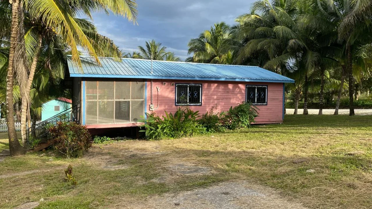
Bullet Tree Falls
2-Bed Wooden Cottage with Screened Porch in Bullet Tree Falls, Cayo
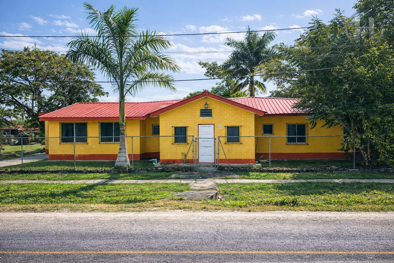
Belmopan
3-Bed 2-Bath Fixer-Upper on Turneffe Avenue, Central Belmopan
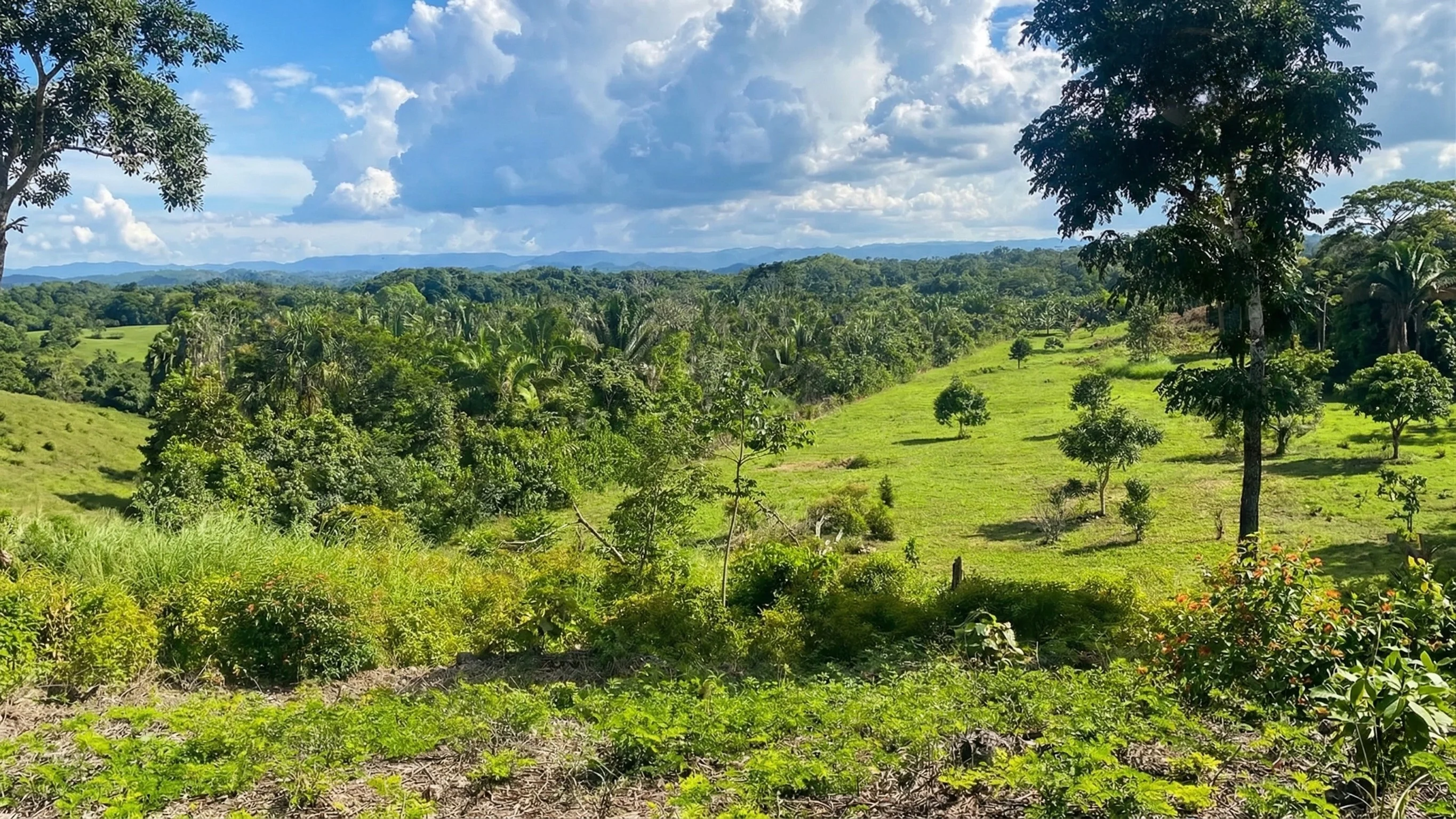
Camalote
30-Acre Hilltop Farm with Mountain Views in Camalote, Cayo
Things to Do & Nearby Attractions
Caracol Maya Archaeological Site
One of the largest Maya cities ever excavated, deep within the Chiquibul Forest. Caracol's main pyramid, Caana, rises 141 feet — still the tallest man-made structure in Belize. A full-day expedition from San Ignacio.
Xunantunich & Cahal Pech
Two major Maya sites within easy reach of San Ignacio. Xunantunich offers panoramic views over the Mopan River valley from atop El Castillo; Cahal Pech sits on a hilltop overlooking the twin towns.
Actun Tunichil Muknal (ATM Cave)
Widely regarded as one of the world's most remarkable cave experiences — a full-day river-wading, swimming, and climbing journey into an ancient Maya ceremonial cave filled with skeletal remains and ceramic offerings.
River Tubing & Kayaking
The Macal and Mopan rivers offer excellent tubing, kayaking, and canoeing routes. The Barton Creek Cave tour — paddling through a cave system by canoe — is one of western Belize's most memorable day trips.
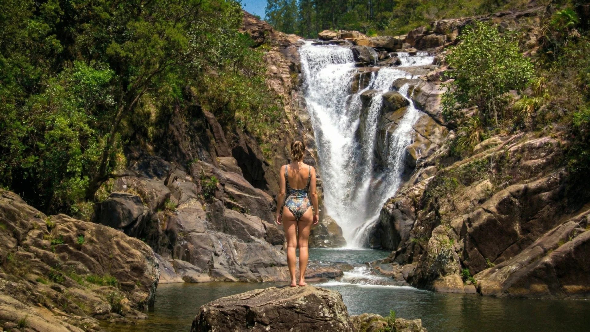
Mountain Pine Ridge & Waterfalls
The reserve's granite plateau holds Thousand Foot Falls (the highest in Central America), the Rio On Pools, and the Rio Frio Cave. A world away from the lowland jungle, accessible in a half-day from San Ignacio.
San Ignacio Saturday Market
One of Belize's best weekly markets — farmers, artisans, street food vendors, and tour operators converge on the town center. An excellent introduction to Cayo's cultural and agricultural diversity.
Getting There & Infrastructure
Air Access
No commercial airport within Cayo. Philip Goldson International Airport in Belize City is approximately 2–2.5 hours east via the George Price Highway. Belmopan Municipal Airstrip handles charter and small aircraft. Many visitors travel onward from Belize City by rental car or shuttle.
Road Access
The George Price Highway is Belize's main east-west corridor, connecting Belize City to San Ignacio and the Guatemalan border in a well-maintained two-lane road. Drive time from Belize City to San Ignacio is approximately 2 hours. Belmopan sits at the midpoint, roughly 1 hour from each.
Infrastructure
BEL grid electricity is reliable in San Ignacio, Belmopan, and the George Price Highway corridor. Water is municipally supplied in the towns; rural and jungle properties typically rely on wells or river intake. Mobile data coverage is strong in the corridor and improving in outlying areas. Medical care is available in San Ignacio (La Loma Luz Hospital) and Belmopan; specialist care is in Belize City.
Ready to Explore?
View Properties in Cayo District
Browse available lots, homes, farms, and waterfront parcels listed in Cayo District, Belize.
View Cayo District Listings